
Optical data
Implemented optical satellites
Satellites |
Class |
Product Types |
Use archive |
Default Resolution |
|---|---|---|---|---|
Sentinel-2 |
L1C & L2A |
Yes |
20m |
|
Sentinel-2 Theia |
L2A |
Yes |
20m |
|
Sentinel-3 SLSTR |
RBT |
Yes |
300m |
|
Sentinel-3 OLCI |
EFR |
Yes |
500m |
|
Landsat 8 OLCI |
Level 1 |
Collection 1: No, Collection 2: Yes |
30m |
|
Landsat 7 ETM |
Level 1 |
Collection 1: No, Collection 2: Yes |
30m |
|
Landsat 5 TM |
Level 1 |
Collection 1: No, Collection 2: Yes |
30m |
|
Landsat 4 TM |
Level 1 |
Collection 1: No, Collection 2: Yes |
30m |
|
Landsat 5 MSS |
Level 1 |
Collection 1: No, Collection 2: Yes |
60m |
|
Landsat 4 MSS |
Level 1 |
Collection 1: No, Collection 2: Yes |
60m |
|
Landsat 3 MSS |
Level 1 |
Collection 1: No, Collection 2: Yes |
60m |
|
Landsat 2 MSS |
Level 1 |
Collection 1: No, Collection 2: Yes |
60m |
|
Landsat 1 MSS |
Level 1 |
Collection 1: No, Collection 2: Yes |
60m |
|
PlanetScope |
L3A & L3B |
Yes |
3m |
|
Pleiades |
SEN, PRJ, ORT & MOS |
Yes |
0.5 or 2m |
|
SPOT 7 |
SEN, PRJ, ORT & MOS |
Yes |
1.5 or 6m |
|
SPOT 6 |
SEN, PRJ, ORT & MOS |
Yes |
1.5 or 6m |
|
GeoEye-1* |
Standard & Ortho |
Yes |
0.3 to 0.6 (PAN or pansharpened), 1.6 to 2.4m (MS) |
|
WorldView-2* |
Standard & Ortho |
Yes |
0.3 to 0.6 (PAN or pansharpened), 1.6 to 2.4m (MS) |
|
WorldView-3* |
Standard & Ortho |
Yes |
0.3 to 0.6 (PAN or pansharpened), 1.6 to 2.4m (MS) |
|
WorldView-4* |
Standard & Ortho |
Yes |
0.3 to 0.6 (PAN or pansharpened), 1.6 to 2.4m (MS) |
* Archived Landsat Collection-1 are not managed because of the tar.gz format, which is too slow to process. It is better to work on the extracted product. * Other Maxar satellites (such as WorldView-1, QuickBird…) with the same file format should be supported.
Warning
Satellites products that cannot be used as archived have to be extracted before use.
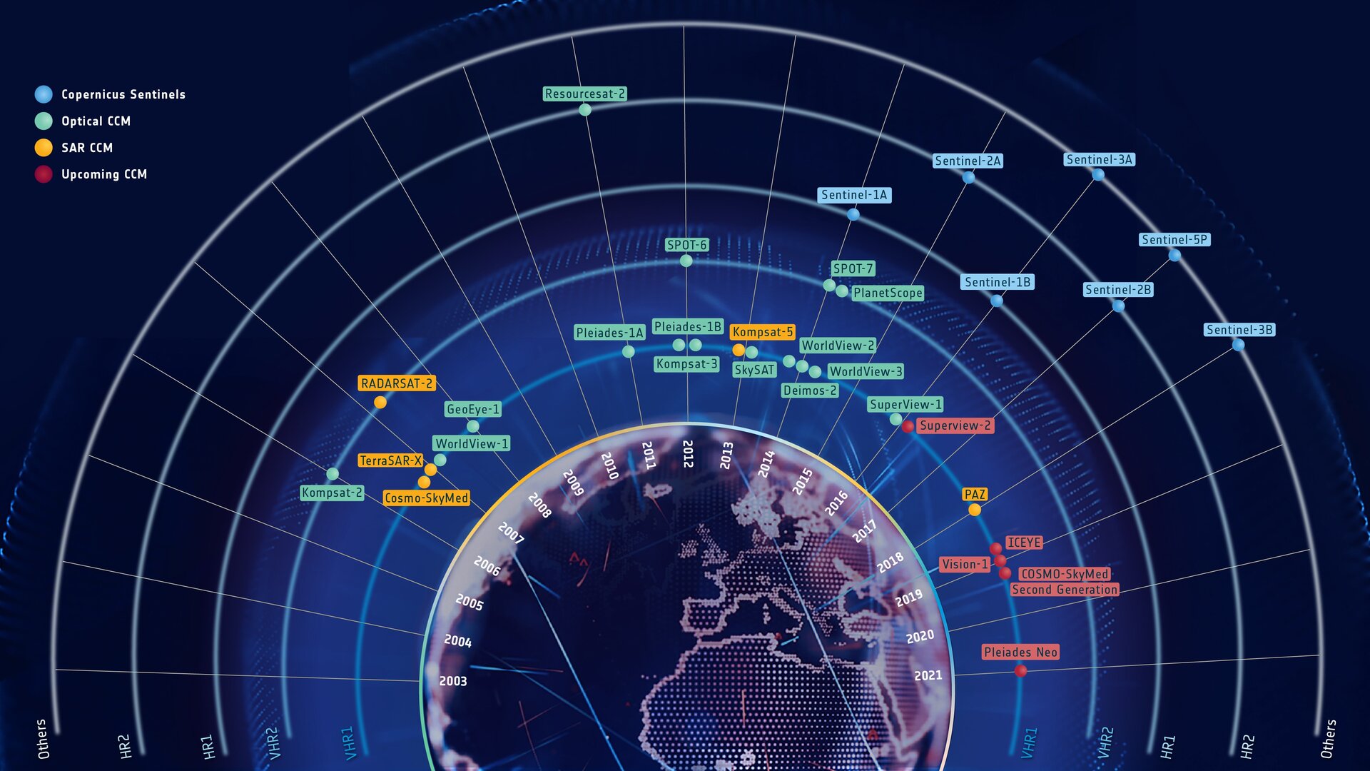
The goal of EOReader is to implement every sensor that can be used in the Copernicus Emergency Management Service.
The sensors that can be used during CEMS activations are (as of 09/2021):
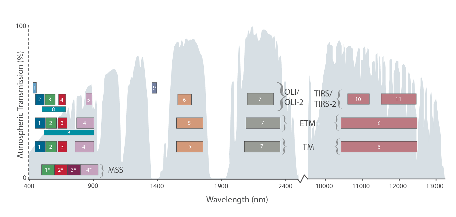
Optical bands
The following bands are available in EOReader, but may not be available for all sensors.
Warning
EOReader loads bands in UTM. VHR bands can be orthorectified but EOReader needs a DEM for that.
Be sure to position the environment variable EOREADER_DEM_PATH to the DEM you want.
Satellite bands
Note
Optical bands are always loaded in reflectance. For Sentinel-3 SLSTR, radiances are converted to reflectance, expcept for brilliance temperature bands that are left as is.
Band names
These bands are mainly based on Sentinel-2 bands with some additions:
CA: Coastal AerosolVRE_1: Vegetation Red Edge 1VRE_2: Vegetation Red Edge 2VRE_3: Vegetation Red Edge 3NIR: Near InfraredNARROW_NIR: Narrow Near Infrared (band8AforSentinel-2)WV: Water vapourPAN: PanchromaticTIR_1: Thermal Infrared 1TIR_2: Thermal Infrared 2
Note
Note that bands that are not mapped can still be used (i.e. for Sentinel-3 OLCI and SLSTR).
They will be called by their true name (i.e. F1 or Oa05). However,
the mapped band will have to be called with their mapped name, i.e. BLUE rather than Oa04 for Sentinel-3 OLCI.
But the bands that are not present in the alias file won’t be recognized.
Optical band mapping between sensors
Bands (names) |
Coastal aerosol |
Blue |
Green |
Yellow |
Red |
Vegetation red edge |
Vegetation red edge |
Vegetation red edge |
NIR |
Narrow NIR |
Water vapor |
SWIR – Cirrus |
SWIR |
SWIR |
Panchromatic |
Thermal IR |
Thermal IR |
|---|---|---|---|---|---|---|---|---|---|---|---|---|---|---|---|---|---|
Bands (alias) |
|
|
|
|
|
|
|
|
|
|
|
|
|
|
|
|
|
Sentinel-2 |
1 (60m) |
2 (10m) |
3 (10m) |
4 (10m) |
5 (20m) |
6 (20m) |
7 (20m) |
8 (10m) |
8A (20m) |
9 (60m) |
10 (60m) |
11 (20m) |
12 (20m) |
||||
Sentinel-2 Theia |
Not available |
2 (10m) |
3 (10m) |
4 (10m) |
5 (20m) |
6 (20m) |
7 (20m) |
8 (10m) |
8A (20m) |
Not available |
10 (60m) |
11 (20m) |
12 (20m) |
||||
Sentinel-3 OLCI* |
2 (300m) |
3 (300m) |
6 (300m) |
7 (300m) |
8 (300m) |
11 (300m) |
12 (300m) |
16 (300m) |
17 (300m) |
17 (300m) |
20 (300m) |
||||||
Sentinel-3 SLSTR* |
1 (500m) |
2 (500m) |
3 (500m) |
3 (500m) |
4 (500m) |
5 (500m) |
6 (500m) |
8 (1km, not managed yet) |
9 (1km, not managed yet) |
||||||||
Landsat OLCI (8) |
1 (30m) |
2 (30m) |
3 (30m) |
4 (30m) |
5 (30m) |
5 (30m) |
9 (30m) |
6 (30m) |
7 (30m) |
8 (15m) |
10 (100m) |
11 (100m) |
|||||
Landsat ETM (7) |
1 (30m) |
2 (30m) |
3 (30m) |
4 (30m) |
4 (30m) |
5 (30m) |
7 (30m) |
8 (15m) |
6 (60m) |
6 (60m) |
|||||||
Landsat TM (5-4) |
1 (30m) |
2 (30m) |
3 (30m) |
4(30m) |
4 (30m) |
5 (30m) |
7 (30m) |
6 (120m) |
6 (120m) |
||||||||
Landsat MSS (5-4) |
1 (60m) |
2 (60m) |
3 (60m) |
3 (60m) |
3 (60m) |
4 (60m) |
4 (60m) |
||||||||||
Landsat MSS (1-3) |
4 (60m) |
5 (60m) |
6 (60m) |
6 (60m) |
6 (60m) |
7 (60m) |
7 (60m) |
8 (240m) |
8 (240m) |
||||||||
PlanetScope (4 band) |
1 (3m) |
2 (3m) |
3 (3m) |
4 (3m) |
4 (3m) |
||||||||||||
PlanetScope (5 band) |
1 (3m) |
2 (3m) |
3 (3m) |
4 (3m) |
5 (3m) |
5 (3m) |
|||||||||||
Pleiades** (PMS/MS) |
3 (0.5/2m) |
2 (0.5/2m) |
1 (0.5/2m) |
4 (0.5/2m) |
4 (0.5/2m) |
||||||||||||
SPOT 6-7** (PMS/MS) |
3 (1.5/6m) |
2 (1.5/6m) |
1 (1.5/6m) |
4 (1.5/6m) |
4 (1.5/6m) |
* Not all bands of this sensor are mapped in EOReader. However, they can still be used by using directly their name (i.e. F1 or Oa05)
** P(panchro) have only one panchromatic band, P/MS-N have 3 bands (BGR), and P/MS-X also have 3 bands in false color (GRNIR)
Click here to see the graph in a larger format.
Cloud bands
Maximum 5 cloud bands are available, according to the files provided in the data. All the bands are rasterized and orthorectified if needed (for Sentinel-2 or 3 data for example), ready to be stacked.
The only difference with the other bands is that the cloud bands are provided in uint8 and have a nodata equal to 255.
RAW_CLOUDS: Raw Cloud file as provided (the only changes are the orthorectification and rasterization). Can provide other flags, or cloud probability.CLOUDS: Cloud presence (1) or absence (0). If clouds are provided in probabilities, their presence is determined according to Landsat definition (proba> 67%)CIRRUS: Cirrus presence (1) or absence (0). If clouds are provided in probabilities, their presence is determined according to Landsat definition (proba> 67%)SHADOWS: Shadows presence (1) or absence (0). If clouds are provided in probabilities, their presence is determined according to Landsat definition (proba> 67%)ALL_CLOUDS: Cloud OR Cirrus OR Shadows presence (1) or absence ( 0). Do not take into account missing bands (i.e. for Landsat MSS sensors,ALL_CLOUDS==CLOUDS)
Satellites |
Clouds Bands |
|---|---|
Sentinel-2 |
|
Sentinel-2 Theia |
|
Sentinel-3 OLCI |
No cloud file available for S3-OLCI data |
Sentinel-3 SLSTR |
|
Landsat 8 |
|
Landsat 7 |
|
Landsat 5 TM |
|
Landsat 4 TM |
|
Landsat 5 MSS |
|
Landsat 4 MSS |
|
Landsat 3 |
|
Landsat 2 |
|
Landsat 1 |
|
PlanetScope |
|
Pleiades |
|
SPOT 6-7 |
|
Maxar (GeoEye-1, WorldViews) |
No cloud file available for Maxar data |
DEM bands
Optical satellites can all load DEM, SLOPE
and HILLSHADE bands.
The SLOPE band is given in degrees.
Please post an issue if you need this band in percent.
Use the environment variable EOREADER_DEM_PATH to position your worldwide DEM. You can
use both a local path e.g. /mnt/dataserver/dems/srtm_30_v4/index.vrt or \\dataserver\DEMS\srtm_30_v4\index.vrt or
a URL pointing to a web resources hosted on a S3 compatible storage e.g.
https://s3.storage.com/dem-bucket/srtm_cog.tif (not available on Windows for now).
Available index
Index |
Needed bands |
Accepted satellites |
|---|---|---|
|
Sentinel-2, Sentinel-3 SLSTR, Landsat OLCI, (E)TM |
|
|
Sentinel-2, Sentinel-3 SLSTR, Landsat OLCI, (E)TM |
|
|
Sentinel-2, Sentinel-3 SLSTR, Landsat OLCI, (E)TM |
|
|
Sentinel-2, Sentinel-3 SLSTR, Landsat OLCI, (E)TM |
|
|
All optical satellites |
|
|
Sentinel-2 |
|
|
Sentinel-2, Sentinel-3 SLSTR, Landsat OLCI, (E)TM |
|
|
All optical satellites |
|
|
Sentinel-2, Sentinel-3 SLSTR, Landsat OLCI, (E)TM |
|
|
All optical satellites except for Landsat MSS |
|
|
All optical satellites |
|
|
Sentinel-2, Sentinel-3 SLSTR, Landsat OLCI, (E)TM |
|
|
Sentinel-2, Sentinel-3 SLSTR, Landsat OLCI, (E)TM |
|
|
All optical satellites |
|
|
Sentinel-2, Sentinel-3 SLSTR, Landsat OLCI, (E)TM |
|
|
Sentinel-2, Sentinel-3 OLCI, Landsat MSS |
|
|
Sentinel-2, Sentinel-3 OLCI, Landsat MSS |
|
|
All optical satellites |
|
|
All optical satellites |
|
|
Sentinel-2, Sentinel-3 SLSTR, Landsat OLCI, (E)TM |
|
|
All optical satellites |
|
|
Sentinel-2, Sentinel-3 OLCI, Landsat MSS, PlanetScope (5 bands), WorldView-2/3 (8 bands) |
|
|
Sentinel-2, Sentinel-3 SLSTR, Landsat OLCI, (E)TM |
|
|
Sentinel-2, Sentinel-3 SLSTR, Landsat OLCI, (E)TM |
|
|
Sentinel-2, Sentinel-3 SLSTR, Landsat OLCI, (E)TM |
|
|
Sentinel-2, Sentinel-3 SLSTR, Landsat OLCI, (E)TM |
|
|
Sentinel-2, Sentinel-3 SLSTR, Landsat OLCI, (E)TM |
|
|
Sentinel-2, Sentinel-3 OLCI, Landsat OLCI, WorldView-2/3 (8 bands) |
|
|
Sentinel-3 OLCI, WorldView-2/3 (8 bands) |
|
|
Sentinel-2, Sentinel-3 OLCI, WorldView-2/3 (8 bands) |
|
|
Sentinel-2, Sentinel-3 OLCI, WorldView-2/3 (8 bands) |